

Original Corners in East Texas
Time limit: 90 days
3 credits
Instructor: Nedra Foster Townsend
Full course description

Course Overview
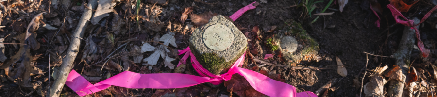
This online continuing education course provides specialized knowledge for locating and documenting original survey evidence in the challenging terrain of East Texas. Led by Nedra Foster Townsend, RPLS, LSLS, the course follows actual boundary retracement work within the Big Thicket National Preserve, demonstrating the complete workflow from archival research through field recovery of corners originally established in 1869.
You will explore research methodologies for East Texas boundary work, including navigating Texas General Land Office records and evaluating timber company archives that often hold the key to perpetuation evidence across multiple survey generations.
Through field demonstrations at original corners along Village Creek, you will observe the professional judgment required when evaluating corner evidence, understanding the hierarchy of natural objects versus artificial monuments, and the importance of perpetuation. The course explores the importance of following the footsteps of the original surveyor, discovering the "Eureka moments" when original witness trees and monuments reveal themselves, and ensuring this evidence remains documented for future generations of surveyors to come.
Professional Benefits
A real boundary retracement case study from the Big Thicket National Preserve
Expert instruction from Nedra Foster Townsend, RPLS, LSLS
Field-based perspective on corner evidence recovery and perpetuation
Learning Outcomes
By completing this course, participants will be able to:
Apply research methodologies for East Texas boundary work, including Texas General Land Office records and timber company archives.
Evaluate corner evidence using the hierarchy of natural objects versus artificial monuments.
Apply the principle of following the original surveyor's footsteps to recover perpetuation evidence in the field.
Document and compile field findings into a professional survey deliverable that reconciles research with field data.
Module Breakdown
Target Audience
- Registered Professional Land Surveyors (RPLS) and Licensed State Land Surveyors (LSLS)
- Surveying professionals preparing for licensure
- General Public interested in East Texas land history
Technical Requirements
- High-speed internet connection
- Modern web browser
- Audio capability for video lectures
- No software installation required
- Optional: printer for supplementary materials
Note: PDH/CEU credit value and passing score to be confirmed. Course access begins immediately upon registration, and content is self-paced within 90 days. Participants are responsible for verifying acceptance with their individual state licensing board.
For registration assistance, contact Shelby Sharpe at shelby.sharpe@tamucc.edu
A Conrad Blucher Institute for Surveying and Science Professional Development Course ©